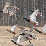
LITTLE ROCK — Arkansas duck abundance is higher than average for the early part of the season, and the season’s first aerial waterfowl survey also revealed an above-average number of mallards for November. Snow goose and greater white-fronted goose numbers also are high.
Arkansas Game and Fish Commission biologists conducted the 2014-15 wintering period’s first aerial waterfowl survey Nov. 17-20 in the Arkansas River Valley, Mississippi Alluvial Valley (Delta) and southwest Arkansas. Observers estimated 993,249 ducks in the Delta, including 547,560 mallards, and a total of 105,682 ducks in the Arkansas River Valley, including 44,271 mallards. The southwest Arkansas duck population estimate was nearly 30,000, almost 16,000 of which were mallards. Observers in the Delta encountered particularly high numbers of arctic geese, including over 2.1 million snow geese and about 446,000 greater white-fronted geese (specklebellies).
The Delta mallard population estimate is nearly double the 2013 November estimate and the 2009-2014 long-term November average. The November total duck population estimate is similar to 2013 and about 100,000 ducks higher than the long-term average. Nearly 50 percent of mallards in the Delta were in the Bayou Meto-Lower Arkansas and Little River Ditches watersheds. The Little River Ditches watershed contains Big Lake National Wildlife Refuge, where biologists encountered high numbers of mallards. Duck concentrations not reflected in this survey include Lake Ashbaugh at Dave Donaldson Black River Wildlife Management Area. The Arkansas River Valley estimates for all ducks and mallards were the highest since formal surveys began in January 2013. The majority of mallards in southwest Arkansas were along the Red River corridor.
About 30 percent of mallards in the Delta were observed in rice fields, and another 24 percent in aquaculture reservoirs, with 14 percent in buttonbush (buckbrush), 8 percent in moist-soil habitat and 7 percent in bottomland-hardwood wetlands. In the Arkansas River Valley, 25 percent of mallards were in rivers, bayous and sloughs, and 23 percent were in moist-soil habitat.
Dry conditions are typical in November, and the landscape was noticeably dry during this survey period with the exception of sheet water in agricultural fields following rainfall in the Delta south of Pine Bluff. Most other habitat was a result of active management by private landowners and public agencies. Duck distribution was patchy, which is typical in dry conditions, but these survey results suggest the unusually cold conditions preceding the survey period brought good numbers of ducks – particularly mallards – to the state.
Additional details about the aerial survey, including graphs and duck density maps, are available at www.AGFC.com.
Northeast Arkansas
Earl Buss Bayou DeView WMA
Map | Water Gauge | Weather Report
Due to the long-term effects associated with extended periods of flooding on timber, the Arkansas Game and Fish Commission will not be pumping the Thompson Tract Greentree Reservoir on Earl Buss Bayou DeView Wildlife Management Area.
South Oliver GTR
Habitat: Mast production has been good.
Water Level: The only water is within the natural slough located on the north end of the GTR and the south end of the North Oliver Tract.
Thompson Tract GTR
Habitat: Mast production has been good.
Water Level: No water.
Lake Hogue WRA
Habitat: A small amount of beneficial wetland plants is located along the east side of the lake.
Water Level: Normal pool level.
Big Lake WMA
Map | Water Gauge | Weather Report
When the Ditch 81 extension gauge near Manilla (upstream of the Big Lake north-end control structure) reads 17.5 feet, water is beginning to come over the north levee degrade on Big Lake WMA. When the Ditch 81 Extension gauge reads 18.0 feet or higher, the water level on the WMA will rise quickly and hunters should exercise caution while on the area. Be aware of underwater logs in boat runs and hangers in trees.
North Woods GTR
Habitat: Mast production is good.
Water Level: Bois d’Arc gauge currently reads 234.2 Target level is 235.5. 20% flooded.
South Woods GTR
Habitat: Mast production is good.
Water Level: The 7-Mile gauge is currently at 233.4 feet. Target level is 234.5 feet with 40% flooded.
Simmons Field
Habitat: A fair amount of millet, smartweed and sedge is present. Seed production is fair.
Water Level: 5%
St. Francis Sunken Lands WMA
Map | Water Gauge | Weather Report
Low water levels along the river channel are making boat navigation difficult. Please exercise caution when accessing the area.
Hunt Area
Habitat: Mast production is above average within the timber and floodways.
Water Level: Water levels in the huntable areas are dependent on the St. Francis River. The water level at Oak Donnick is 206.86 feet with 25% of the huntable area flooded.
Snowden WRA
Habitat: There is a small amount of beneficial wetland plants within the borrow areas.
Water Level: No water.
Payneway WRA
Habitat: There is a small amount of beneficial wetland plants within the borrow areas. Pools A, B, C, Pool D have no water.
Water Level: No water.
Shirey Bay Rainey Brake WMA
Map | Water Gauge | Weather Report
Waterfowl hunters should be aware of hangers and submerged logs within the boat runs and GTRs. Please exercise caution when accessing the area. In addition, hunters should allow safe passage when parking vehicles along roadsides. Vehicles blocking access will be moved.
Adam’s Brake GTR
Habitat: Good mast crop within the GTR.
Water Level: Water level is 238.2 MSL with a target level of 240.0 MSL. 70% flooded.
Rainey Brake GTR
Habitat: Good mast crop within the GTR.
Water Level: 90%
Eagle Pond GTR
Habitat: Good mast crop.
Water Level: 85%
Phase III Moist-soil Unit
Habitat: Average wetland-type vegetation.
Water Level: No water.
Charles Crisp Moist-soil Unit
Habitat: Good wetland-type vegetation.
Water Level: No water.
Ward Field Moist-soil Unit
Habitat: Average wetland-type vegetation.
Water Level: No water.
River Field Moist-soil Unit
Habitat: Good wetland-type vegetation.
Water Level: No water.
Dave Donaldson Black River WMA
Map | Water Gauge | Weather Report
Waterfowl hunters should be aware of hangers and submerged logs within the boat runs and GTRs. Please exercise caution when accessing the area. Please remember to keep boats off the levees so AGFC personnel can access the area. Boats blocking access will be moved. Unattended trailers are not to be left overnight on parking areas.
Upper Island GTR
Habitat: Good abundance of mast crop within the GTRs.
Water Level: Water level is 269.2. Target level is 269.5 MSL. 95% flooded.
Lower Island GTR
Habitat: Good abundance of mast crop within the GTRs.
Water Level: Water level is 268.2. Target level is 268.0 MSL. 100% flooded.
Upper Reyno GTR
Habitat: Good abundance of mast crop within the GTRs.
Water Level: Water level is 267.1. Target level is 266.9 MSL. 100% flooded.
Lower Reyno GTR
Habitat: Good abundance of mast crop within the GTRs.
Water Level: Water level is 265.8. Target level is 266.3 MSL. 90% flooded.
Winchester GTR
Habitat: Good abundance of mast crop within the GTRs.
Water Level: Water level is 263.3. Target level is 263.7 MSL. 80% flooded.
East Central Arkansas
Sheffield Nelson Dagmar WMA
Map | Water Gauge | Weather Report
The Conway George units are available by applying for online permits. Permit hunts are on Wednesday and Saturday. Please visit www.AGFC.com for maps, special regulations, permit application and draw dates. Hunters should call the Wildlife Hotline at 800-440-1477 for current road closures.
Mud Slough GTR
Habitat: Good mast crop.
Water Level: No water.
Apple Lake WRA
Habitat: Good mast crop.
Water Level: 80%
Conway George Waterfowl Unit A
Habitat: Excellent stand of millet and native vegetation.
Water Level: No water.
Conway George Waterfowl Unit B
Habitat: Natural slough area with beneficial wetland plants
Water Level: 45%
Conway George Waterfowl Unit C
Habitat: Excellent stand of millet and native vegetation.
Water Level: 100%
Rex Hancock Black Swamp WMA
Map | Water Gauge | Weather Report
Hunters should call the Wildlife Hotline at 800-440-1477 for current road closures.
Main WMA
Habitat: Good mast crop.
Water Level: No water.
Wyeville Unit
Habitat: Good stand of millet and native vegetation.
Water Level: 100%
Lee LeBlanc Unit
Habitat: Good stand of native vegetation.
Water Level: 0%
Steve N. Wilson Raft Creek Bottoms WMA
Map | Water Gauge | Weather Report
Holes 4, 7, 8, 9, 10, 11, 12, 13, 14, 18, 22 and 28 have huntable water. All are easily accessible by boat (except for hole 4 and 7) although a surface drive would be ideal. For the most part, holes 11 and 14 will be restricted to hunting the boat lane near the big willows . Holes 29 and 30 on Heathscott Road only have water in the potholes within the units. Holes 1, 2, 3, 5, 15, 16, 17, 19, 20, 21, 23, 24, 25 and 26 do not have huntable water. Hole 27 has water in the potholes around the hole sign and there have been ducks in this area.
Unit A
Habitat: Excellent stand of millet and native vegetation.
Water Level: No water.
Unit B
Habitat: Excellent stand of millet and native vegetation.
Water Level: 40%
Unit C
Habitat: Excellent stand of millet and native vegetation.
Water Level: No water.
Unit D
Habitat: Good stand of millet and native vegetation.
Water Level: 65%
Unit E
Habitat: Good stand of millet and native vegetation.
Water Level: 50%
Unit F
Habitat: Excellent stand of millet and native vegetation.
Water Level: No water.
Unit G
Habitat: Habitat conditions are poor.
Water Level: 5%
Unit H (Mobility-impaired blind)
Habitat: Excellent stand of millet and native vegetation.
Water Level: 100%
Unit I
Habitat: Good stand of millet and native vegetation.
Water Level: 15%
Henry Gray Hurricane Lake WMA
Map | Water Gauge | Weather Report
Hunters should call the Wildlife Hotline at 800-440-1477 for current road closures.
North GTR
Habitat: Good mast crop.
Water Level: No water.
South GTR
Habitat: Good mast crop.
Water Level: No water.
Southwest Arkansas
Sulphur River WMA
Mercer Bayou
Habitat: Habitat conditions are good.
Water Level: The area is three inches below normal.
Henry Moore WRA
Habitat: Closed to hunting.
Water Level: 80%
Millwood Lake
Map | Water Gauge | Weather Report
Habitat: Habitat conditions are good.
Water Level: 259.67 MSL.
Dr. Lester Sitzes III Bois d’ Arc WMA
The water level in the GTR is still increasing.
Bois d’Arc Lake WRA
Habitat: Closed to hunting.
Water Level: Low
Red Slough WRA
Habitat: Closed to hunting.
Water Level: 15%
GTR
Habitat: Good mast production.
Water Level: 60%
Little Grassy
Habitat: Habitat is fair.
Water Level: 5%
Central Arkansas
Craig D. Campbell Lake Conway Reservoir
Habitat and water levels are normal on both Pierce and Dix Creeks.
Harris Brake WMA
Harris Brake GTR
Habitat: Good mast crop.
Water Level: 95%
Holland Bottoms WMA
Hunt Area
Habitat: Good mast crop.
Water Level: No water.
Lake Pickthorne WRA
Habitat: Excellent.
Water Level: East cell is 100%. West cell is dry.
Bell Slough WMA
Bell Slough GTR
Habitat: Fair mast crop.
Water Level: 100%
Palarm Creek WRA
Habitat: Vegetation is limited due to recent construction projects within the rest area.
Water Level: 50%
Southeast Arkansas
Beryl Anthony Lower Ouachita WMA
There has been good soft and hard mast crop production on the WMA. There is minor flooding on the area, mostly in sloughs and oxbow lakes. Less than 10% of the area is flooded.
Freddie Black Choctaw Island WMA Deer Research Area
Map | Water Gauge | Weather Report
Habitat conditions are good. There is variable flooding associated with the Mississippi River. Mississippi River is at 6.3 feet and rising on the Arkansas City gauge.
Trusten Holder WMA
Map | Water Gauge | Weather Report
Habitat conditions are good. Variable flooding on the WMA. Arkansas River is at 26.4 feet on the Pendleton gauge. Variable flooding associated with the White and Arkansas rivers.
Seven Devils Swamp WMA
Hunt Area
Habitat: Habitat conditions are good.
Water Level: No water.
Cut-Off Creek WMA
Hunt Area
Habitat: Habitat conditions are good.
Water Level: 20%
Pigeon Creek WRA
Habitat: Habitat conditions are good.
Water Level: Pumping will begin as creek levels allow.
Bayou Meto WMA
Upper Vallier GTR
Habitat: Good
Water Level: 177.4 feet. Full pool is 180 feet. No water.
Lower Vallier GTR
Habitat: Good
Water Level: 177.4 feet. Full pool is 179 feet. Some water is in the lower sloughs. Use caution around water control structures.
Government Cypress GTR
Habitat: Good
Water Level: 177.4 feet. Full pool is 179 feet. Some water is in the lower sloughs.
Buckingham Flats GTR
Habitat: Good
Water Level: 100%
Temple Island GTR
Habitat: Good
Water Level: 100%
Canon Brake
Habitat: Good
Water Level: 169 feet. Full pool is 177 feet. No water. Use caution around water control structures.
Halowell WRA
Habitat: Good
Water Level: Staggered unit flooding.
Wrape Plantation WRA
Habitat: Good
Water Level: Staggered unit flooding.
Northwest Arkansas
Dardanelle WMA
The green tree area of the Johnson County WRA is not being flooded this year.
Johnson County WRA
Habitat: Moist soil and green trees.
Water Level: 50%
McKennon Bottoms
Habitat: Moist soil.
Water Level: 100%
Potter’s Pothole Hartman Waterfowl Unit
Habitat: Corn and millet.
Water Level: 100%
Ozark Pool
Dyer Lake Cells
Habitat: Millet and moist soil.
Water Level: Unit 1 has no water because of a leak and Unit 2 is at 100% of capacity.
Lloyd Millwood Nimrod WMA
Nimrod GTR
Habitat: Good mast crop. The fields have native grasses.
Water Level: 5%
Frog Bayou WMA
Unit 1
Habitat: Under renovation.
Water Level: 100%.
Unit 2
Habitat: Under renovation.
Water Level: No water.
Unit 3
Habitat: Under renovation.
Water Level: No water.
Unit 4
Habitat: Under renovation.
Water Level: No water.
Unit 5
Habitat: Good stand of native millet.
Water Level: 100%.
Unit 6
Habitat: Good stand of smartweed and native millet.
Water Level: 100%
Unit 7
Habitat: Good stand of smartweed and native millet.
Water Level: 100%
Galla Creek WMA
Galla Creek GTR
Habitat: Natural vegetation inluding a mixutre of barnyard and smartweed.
Water Level: No water. Flooding is planned to begin on Dec. 1.
Petit Jean River WMA
Map | Water Gauge | Weather Report
Santa Fe GTR
Habitat: Good mast crop.
Water Level: 10%
Olin Cain Moist-soil Unit
Habitat: Mix of millets and native grasses.
Water Level: 100%
Black Lands Moist-soil Unit
Habitat: Mix of millets and native grasses.
Water Level: 90%
Slaty Crossing Moist-soil Unit
Habitat: Mix of millets and native grasses.
Water Level: 5%
Pullen Pond
Habitat: Mostly sedges.
Water Level: 5%
Pond Creek GTR
Habitat: Good mast crop and millets.
Water Level: 5%
Slaty Pond GTR
Habitat: Good mast crop.
Water Level: 5%
Black Lands Duck Area
Habitat: Mix of millets and native grasses.
Water Level: 100%
Ed Gordon Point Remove WMA
About half of all waterfowl impoundments are near or at capacity. Nearly all impoundments have good to excellent stands of natural vegetation, including smartweed and wild millet. Duck use on the area is currently low to moderate and hunter success on the area has been poor to fair. Pumping of additional acreage will continue as water levels in Point Remove Creek permit.
Willow Island
Habitat: Natural vegetation.
Water Level: 100%
Little Hole
Habitat: Golden grass and brown top millet.
Water Level: 10%.
Red Gate
Habitat: Natural vegetation.
Water Level: 90%
Pig Trough
Habitat: Natural vegetation.
Water Level: 100%
Cedar Ridge
Habitat: Natural vegetation.
Water Level: 100%
Duck Trap
Habitat: Natural vegetation and Japanese millet.
Water Level: No water.
Salt Lick
Habitat: Natural vegetation.
Water Level: 70%
Bobby’s Pond
Habitat: Natural vegetation.
Water Level: 100%
Race Track
Habitat: Natural vegetation.
Water Level: 100%
Controversy Corner
Habitat: Natural vegetation.
Water Level: 90%
Remmel Marsh
Habitat: Natural vegetation.
Water Level: 90%
Mud Pond
Habitat: Natural vegetation.
Water Level: No water.
Turkey Pond
Habitat: Natural vegetation and Japanese millet.
Water Level: No water.
Teeny Pond
Habitat: Natural vegetation.
Water Level: No water.

Related Posts
 60 Days of Ducks – AGFC Approves Arkansas Duck Season Dates
 Calling All Duck Hunters: Feedback Sought for 2015 Arkansas Waterfowl Season
- Arkansas Waterfowl Report – Pieces Coming Together for Duck Hunters
 Cold Weather Arrives Early For 2014 Arkansas Duck Season
- Rex Nelson: Sun Setting on Arkansas Duck Season
- Arkansas Duck Numbers Have Dropped; Habitat Conditions Improving